Indianapolis and surrounding areas over the Aug. 14 weekend faced a flood event not seen in more than 30 years.
President Donald Trump approved a Presidential Emergency Declaration for Indiana after a Saturday afternoon call with Gov. Mike Braun. On Saturday evening Indianapolis officials said the White River reached peak flooding levels on the north side of the city.
Residents who need a safe place to shelter can go to a Red Cross-staffed shelter at Washington Township Schools Services Center, 8401 Westfield Blvd.
For text updates on flooding from the city, text INDYFLOOD26 to 67283.
If a roadway is flooded, DO NOT attempt to cross it — three inches can take someone off their feet, six inches can stall any vehicle, and eight inches can wipe a vehicle off a road.
Tuesday, 10 p.m.
Many residents can return home if they feel safe
City officials issued a statement that residents can return if flood water receded from the home and they feel safe doing so.
"Emergency officials cannot stress enough how cautious residents should be in being aware of their surroundings and not putting themselves in a situation where they may need assistance," the statement said.
But as of 6:30 p.m. Tuesday there is still standing water in the Ravenswood neighborhood and east of Keystone Avenue between 78th and 80th streets "...that will preclude entering safely," the city said.
If power was disconnected at a home, residents are urged to contact utility provider AES Indiana to ask for an assessment whether the power can be turned on.
"AES will make the final determination if the house can be re-powered safely," the statement said. "If it cannot, they will give the homeowner instructions on the steps to get power restored."
Monday, 5:30 p.m.
White River continues to decline
As of Monday afternoon, the White River is measuring 15.87 feet at the highest location, according to the Indianapolis Department of Public Works. The river is flowing at a continued slow decline. Most floodgates are reopened across Marion County.
City engineers are still actively monitoring river levels to determine when gates at Troy Avenue and Harding Street, and other gates in the Broad Ripple neighborhood can be opened.
Sunday, 5:10 p.m.
City officials ask Ravenswood residents not to return home
Some Indianapolis residents should not return to their homes until Tuesday — that's the latest advice from city officials after a flood forced residents to evacuate from neighborhoods along the White River.
The city is advising residents in the Ravenswood neighborhood to wait for an official notice to return.
Waters have begun to recede in several north side neighborhoods, but officials say that doesn't mean the area is safe. The city also announced it created a page on its website to list resources for assistance and donations, and to provide updates on the flooding.

Sunday, 3:05 p.m.
Coming home to survey the damage
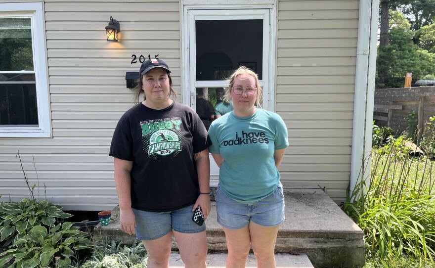
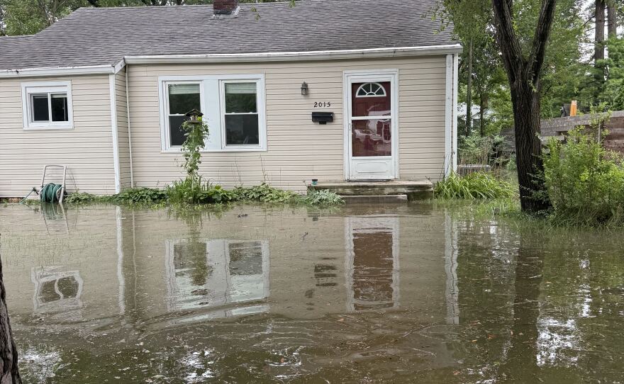
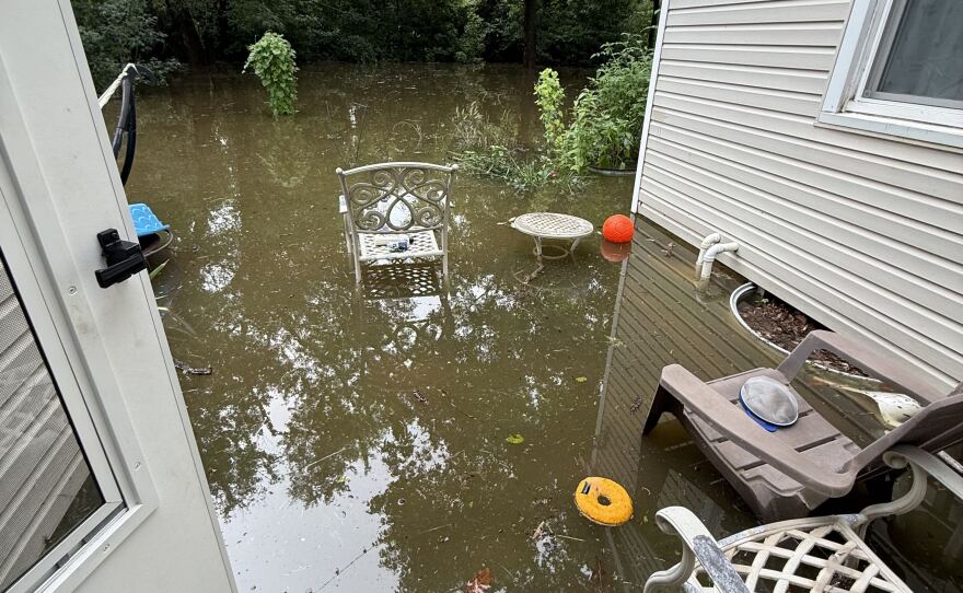
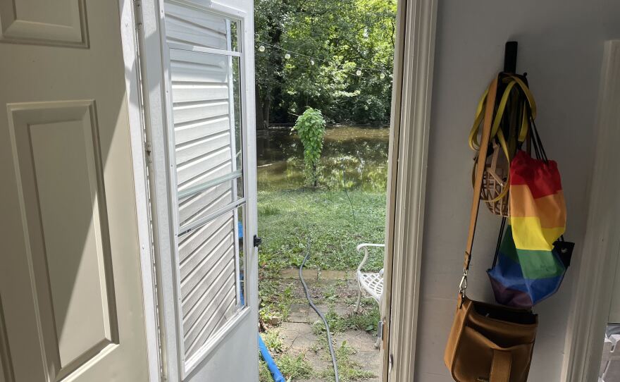
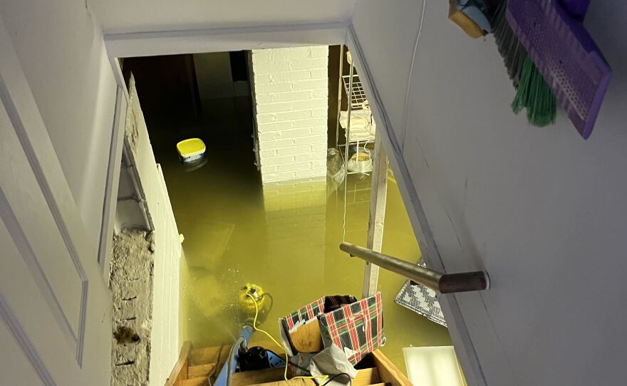
Sunday, 2:20 p.m.
'We're opening up these gates because it's finally safe to do so.'
City workers Sunday afternoon removed the floodgate on 67th Street that protects Broad Ripple from flooding on the White River. The move signals that the city believes the worst of the flooding is over.
“We’re opening up these gates because it’s finally safe to do so,” Mayor Joe Hogsett said. “The water has crested here on the north side and on the south side.”
Hogsett said he and city workers will travel across the city to visit neighborhoods and assess the damage.
Residents in flooded neighborhoods across Indianapolis are being told to wait for the city to give the go-ahead to return home.
Todd Wilson is director of the Department of Public Works for Indianapolis. He said the river crested at 21.18 feet on 82nd Street over the White River. That’s just below the previous high of 22.4 feet recorded in 1913.
“We’re one foot below that,” Wilson said.
Rusted Moon Outfitters and Plump’s Last Shot remained open Sunday afternoon even though the street was flooded outside their Broad Ripple storefronts.
Jonathan Plump is the owner of Plump’s Last Shot.
“We have the river running through our front yard,” Plump said. “The beer’s cold and that’s about the most important thing.”
Plump said the neighborhood has come together in the midst of the flooding.
“This little community is very good at that,” he said.
Next door at Rusted Moon, employee Brandon Smart said the community came out to help put sandbags in front of the business.
“We saw the community show up for our business,” Smart said. “We had longtime customers, and good neighborhood folks that know us, literally bring over sandbags.”
Smart said their councilman John Barth was also running around the area to help people out.
“Huge to us and huge to keeping our operations going,” Smart said.

Sunday, 1:40 p.m.
Sunshine Gardens on the city's south side
Mayor Joe Hogsett and city emergency response officials on Saturday said four south side communities at risk of flooding should make plans to evacuate if needed.
Residents of one of those neighborhoods, Sunshine Gardens, told WFYI Saturday afternoon they had never seen the river that high. At the Harding Street Station owned by AES, the nearest monitoring station upstream of the neighborhood, the river had reached 13.61 feet at 4:30 p.m., according to data from the U.S. National Oceanic and Atmospheric Administration.
At around 1:15 a.m. early Sunday, the river crested at the station at 14.47 feet, which the federal agency describes as moderate flooding. But by around noon on Sunday it appeared that the embankment along the White River had held through the night, according to one resident WFYI reached by phone.

Twilla Duvall-Parks has lived in Sunshine Gardens for over 50 years, and her home is close to the levee. They have horses and other animals, so it would have been a challenge to relocate, but she said the river did not breach the neighborhood.
“Everything is how it was in our neighborhood. Further south, it has come up toward Wicker Road,” Duvall-Parks said.
She said the Indiana Department of Natural Resources was at the river in the neighborhood Saturday. When WFYI spoke with residents, one said she witnessed a person swept down the river by floodwaters. WFYI reporter Zak Cassel witnessed about three DNR conservation officers on the scene.
Parks-Duvall said when she later visited the river that number had grown to seven. WFYI has followed up with DNR staff and requested records, but could not reach department staff as of Sunday afternoon.
Like other neighborhood residents WFYI spoke with Saturday, Parks-Duvall said the city did not reach out to her family about the flooding risk.
“We never heard anything from the city as far as them coming to us,” she said. She wondered why, if there was risk to the neighborhood, the city didn’t bring sandbags to reinforce the levee.
At the power plant to the north, the river had receded to 13.24 feet by 12:45 p.m. Sunday, NOAA monitoring data shows — still a moderate risk.
Sunday, 11:35 a.m.
Flooding impacts roadways in Carmel
A bridge on Hazel Dell Parkway was completely washed out. The roadway failed when waters gushed under the bridge and all four lanes caved in.
Carmel Mayor Sue Finkam said fixing the road was a top priority in a press conference Sunday morning.
Hazel Landing Park was still underwater as the flooding started to recede.
All parks along the White River in Carmel remain closed.
Former long-time Carmel Mayor Jim Brainard was at the scene of the Hazel Dell Parkway washout Sunday morning. He said the thoroughfare was one of the first major infrastructure projects he prioritized.
He reacted to seeing the roadway collapsed right where it began nearly 20 years earlier.
“Disappointing to see, because Hazel Dell Parkway was actually the first project I worked on. As mayor we designed it in 1996 and started building the section south of 106th in 1997,” Brainard said.

Saturday, 9:30 p.m.
Community turns out for Rocky Ripple
Hundreds gathered at a sand volleyball court at Hohlt Park in Rocky Ripple, armed with shovels, buckets and wheelbarrows.
They filled sandbags to reinforce parts of the levee around the neighborhood. Around 8:45 p.m., a man announced there was a breach on 54th Street. Dozens left carrying sandbags filled from the volleyball court.
The flooding hadn't swept the neighborhood, but water was topping some parts of the levee due to unevenness and percolating the soil some, said Margaret Brabant, who has lived in Rocky Ripple since 1992. She wore a yellow life jacket and directed cars of people who had shown up to help, many of whom she said were not from Rocky Ripple.
"This is pretty overwhelming, because the generosity is just stunning," Brabant told WFYI, almost tearing up.

Rocky Ripple Town Councilor Megan Hulland was helping out at Hohlt Park. She said although the city said waters had crested on the north side of Indianapolis, they're seeing it rise a little bit.
"We're holding the line, but we're out of sandbags," she said. She said they exhausted DPW's sandbags and the ones they had on hand. Some are on the way from Shelby County, but it will take some time.
But soon after, Rocky Ripple Town Council President Randy Sanders got a text message telling him more than 1,000 additional sandbags were on the way.

Saturday, 8:35 p.m.
Floodwater begins to recede
The White River reached peak flooding levels on the north side of Marion County, according to city stormwater engineers.
The Department of Public Works reported the peak isn't the end of the emergency response work but the start of the next phase of flood watching. Data shows the peak water levels will hold for a few hours before floodwater begins to recede. City engineers will closely monitor levees and flood control gates to ensure it operates correctly.
Floodwaters will continue moving downstream, bringing potential flooding to the south side. River gauges are expected to peak at Raymond Street around 2 a.m. Sunday, according to the department.
Stormwater engineers will continue to monitor four south-side neighborhoods — including Sunshine Gardens and Hi-Acre Manor — to determine what additional actions may be needed.
The city is transitioning families with pets from the Broad Ripple Family Center to the Noble Shelter at 2406 N. Tibbs Ave. Southside families can also use this shelter if evacuation is needed.
Earlier projections showed a crest of 21.4 feet on the White River at the 82nd Street bridge around 8 p.m.
The Indianapolis Foundation is collecting donations to provide assistance to local residents affected by the flood event. Donations can be made here.
Saturday, 6:30 p.m.
Sunshine Gardens and south side communities on alert
Sunshine Gardens is a small neighborhood on the south side bounded by the White River to the east and I-465 to the north. A densely-wooded stretch of trees covers a high embankment between homes and the river. People use a dirt road to access the river for fishing.
This afternoon, residents came and went to the embankment to check out how much the river had risen and talk with each other. A handful of residents told WFYI that city officials hadn’t reached out directly to alert them of the flooding risk. Instead, they heard from each other or the local news. One resident called Sunshine Gardens a “forgotten neighborhood.”
At a press conference earlier in the afternoon, city officials said the neighborhood and three other southside areas — Southport Roads, the East side of the river south of Raymond Street and Hi-Acre Manor — are at risk of flooding later Saturday. The Department of Public Works said residents should have a plan to leave if evacuations become necessary.

James Duvall, an evangelist at Trinity Baptist Church, said he’s lived in the neighborhood for over forty years.
“I’ve never seen the water this high,” Duvall said.
WFYI did not find signs that flooding had reached neighborhood streets around 4:30 p.m. Saturday, but city officials expect the river to continue rising into the evening.
Saturday, 4:10 p.m.
Braun gives update, Trump pledges support
Gov. Mike Braun said President Donald Trump will approve a Presidential Emergency Declaration for the state, following a call between the two Saturday afternoon. The declaration will free up to $5 million in federal funds to support the state's response to the current floods and storms.
“I spoke with President Trump today about the devastation we’re seeing across Indiana, and I’m grateful to the President for quickly addressing my request and providing additional resources to help Hoosiers,” Braun said in a statement. “My heart is with the families and loved ones of the five Hoosiers we have lost and every family whose life has been changed by these storms. Please continue to take flooding seriously and stay away from floodwaters.”

Braun said the Indiana National Guard, state agencies and emergency response teams are working alongside local officials and first responders across the state.
"Our response is fully mobilized, and we will continue putting every available resource behind keeping Hoosiers safe and helping our communities recover," he said.
The federal declaration will help cover the cost of water rescuers, sandbagging, evacuations, shelters, emergency supplies and more.
More than 350 evacuations have occurred in Delaware County. Braun declared a statewide disaster emergency Thursday. Local disaster declarations have since been enacted in 15 counties, including Marion County, and in municipalities in Hamilton County, including Carmel and Noblesville.
Saturday, 3:00 p.m.
Bracing for the crest
Rocky Ripple Town Council President Randy Sanders attended the city’s press conference. He said, about an hour beforehand, the water was about a foot from the top of the levee and still rising.
His best guess is about 90% of the neighborhood has evacuated.
Rocky Ripple Town Councilor Megan Hulland said there are varying reasons people want to stay.
“We have a community that’s lived in a floodplain for a very long time,” she said. “Some probably are just not sure that this is going to overtop the levee. Some people don’t want to leave the community. I think others are still watching and waiting to see what’s going to happen.”
Sanders said, last he knew, the roads looked fine.
“One of my concerns right now is that we have a lot of people that are lower income. If there’s any places in the Broad Ripple area that could reach out to the town of Rocky Ripple, say, ‘Hey, we can help feed people if they want to come here,’ we would greatly appreciate that,” Sanders said.
Rocky Ripple has about 630 residents.
“It’s like living in the country in the middle of the city, and you won’t meet a group of nicer people that will wave at you. You know each other’s dogs,” Sanders said. “It’s not a town. It’s what a community is.”

Further north on the White River, conditions continue to worsen in Ravenswood. WFYI reporter Sam Horton could not get into the neighborhood around 1:00 p.m. And she found people evacuating from a neighborhood nearby in knee-high water.
Lisa Lamott has lived on Crittenden St. just west of Ravenswood since the 1980s. She said she was notified to evacuate around 12:30 p.m.
"So '91 was usually probably the worst flood we've seen," Crittenden said. "But this is really bad this time. I mean, we've never been flooded out before. Usually, it came up maybe to our driveway, and people would launch boats from there. But now it's dire."
Horton reports there are fish in the water, and some people are using Kayaks and boats to evacuate.
In Carmel, fire officials said they evacuated about 40 people as of noon Saturday. More than 20 horses were also evacuated from an equestrian center along River Rd.
Resident Delaney Cawley lives in her grandfather's home in the neighborhood just west of the White River that was evacuated.
"I've never seen anything like this happen before," she said.

Cawley spoke with WFYI earlier in the day and said her grandfather, uncle and brother were still in the house while water was slowly coming inside. She was in contact with them by phone.
"I think they're trying to stay until the last second possible unfortunately, but I think they need to get out as soon as possible," she said.
Carmel Fire Public Information Officer Tim Griffin did not call it a mandatory evacuation. He said Fishers and Noblesville emergency response teams have helped with evacuations. Carmel officials were not sure if the river had crested yet as more rain hit the area early Saturday morning and afternoon.
Saturday, 2:20 p.m.
City officials warn it will get worse, look to south side
The city faces a flood event we have not seen in more than 30 years, and the National Weather Service reports we are quickly approaching a 100-year flood event.
Projections showed a crest of 21.4 feet high at the 82nd Street bridge around 8 p.m.
Mayor Joe Hogsett and city department leaders reported updates at the IMPD East District headquarters.

Hogsett warned the situation is escalating and conditions can rapidly change.
“Let me be absolutely clear, the residents in Ravenswood, Rocky Ripple, and other areas impacted by flooding — please leave your homes now. This is not a time to wait,” he said.
He urged people to subscribe to text alerts from the city for flooding updates.
Marion County Emergency Management Director Jacob Spence said residents in all areas around the White River must be on guard.
“If you normally see floodwater, you definitely need to leave, and if you’re in an area that’s near but normally does not see it, we would ask you to leave now. Make preparations, make a plan,” Spence said.
Officials also warn areas on the South Side need evacuation plans now. They are at risk of flooding later, as the crest moves down the river.
Department of Public Works Director Todd Wilson said those include: Sunshine Gardens bounded by I-465 to the north, Epler Avenue to the south, Warren Avenue to the east, and the White River to the west; Highacre Manor neighborhood, west of the White River, north of I-465; Southport Road between the White River and Tibbs, including the Indian Lakes Campground; and the east side of the White River, south of Raymond Street, bounded by east of West Bluff Road and Southern Avenue to the south.
“The water is still rising, and it will be rising all day long,” Wilson said.
IFD has rescued 38 individuals in Ravenswood, Rocky Ripple and the nearby area, said Deputy Chief Jerry Martin. IFD currently has six water rescue teams operating. The department estimates about 400 people are evacuated from the Ravenswood area, and that number is probably higher now.
“We cannot make anybody leave their residences, or we do not have currently any mandatory evacuations,” Martin said. “But we are highly, highly suggesting for folks, if you’re in those areas, please have a plan in place and evacuate those areas for flooding.”
Martin said to turn around instead of driving through a flooded roadway: three inches can take someone off their feet, six inches can stall any vehicle and eight inches can wipe a vehicle off a road.
The city, in partnership with the state, requested and received two National Guard vehicles to help the Indianapolis Fire Department with rescues. Spence, with emergency management, said the state is requesting a FEMA disaster declaration.
Saturday, 12:45 p.m.
Evacuations continue: Indianapolis, Carmel
Indianapolis Fire Department reports one man was transported to a hospital after attempting to evacuate the 78th Street area on his own. He “lost steam and neighbors jumped in to assist to no avail,” the department said in a statement.
In Carmel, emergency officials are evacuating people in a neighborhood near the White River. Boats were brought to the scene at 122nd and River Rd to assist in the effort.

Families with loved ones still inside houses waited where the road was closed for instructions on the process.
Near Broad Ripple, Remaining Ravenswood and Rock Ripple residents are strongly urged to evacuate. This city cannot force people to evacuate.
To Rocky Ripple residents, the Indianapolis Department of Public Works said it’s closely monitoring the 53rd street floodgate, and if closure is required, “vehicles—including emergency vehicles—will not be able to access the area.”

The 52nd Street gate to the area was closed. There was flooding on Westfield Avenue. Flood water was not visible in Holcombe Gardens.
In Broad Ripple, at the Monon Trail bridge just north of 67th Street (where crews put flood gates up last night), the White River touched the bottom of the bridge.
Hours before flood waters were expected to crest on the White River, many people were out observing the scene.
Mason Hurless was out on a bike ride with friends Eric Reinertsen, Amanda Rooksbery and Ashley Black. Hurless said he runs a lot on the Monon Trail and has seen some flooding over the years.
"There was a couple of years ago, there was a somewhat higher flood. This is this is insane," Hurless said.
He and Reinersten went to college near the Mississippi River. "This looks like the Mississippi right now. This is the most insane flood I've ever seen," he said.

While the floodgates protect Broad Ripple, residents north of the White River are without the same protections. Doug Overbay said he has concerns his home will flood and is staying alert.
"We've got three stories, so tonight we're going to sleep on the third floor," Overbay said.
The National Weather Service issued a flash flood warning in effect from 10:12 a.m. until 3:15 p.m. for the entire Indianapolis metropolitan area.
It says the latest data forecasts the White River to crest between 2 p.m. and 8 p.m.
DPW does not have a complete list of impacted roadways. If a roadway is flooded, DO NOT attempt to cross it.
Saturday, 8:45 a.m.
Floodgates and road closures
Overnight, city workers closed the floodgates surrounding the Edgewood Apartments and Indy Art Center on East 67th Street in Broad Ripple.
The 53rd Street gate in Broad Ripple is being monitored for possible closure, according to the Department of Public Works. If the gate is closed, it means residents and emergency crews will no longer be able to access the homes or the area.

DPW also closed 96th Street and Brandt Road due to flooding that caused the road to fail. Officials are also monitoring Westfield Boulevard for a potential closure. That is not a complete list of closed roadways, the department said.
Friday, 10:20 p.m.
'There's no sense in waiting. People need to get out now.'
Rocky Ripple Town Council President Randy Sanders told WFYI the town has spent two days bracing for what could be its worst flood in more than a century.
Volunteers filled three tons of sand in 1,000 sandbags by 7:30 p.m. Friday, he said. But that work stopped after city officials told them the sandbags wouldn't hold the water back. Sanders said leftover bags were given to residents to use for their homes.

Sanders said the projected crest will cause the worst flooding Rocky Ripple has seen since 1913, and the highest water the town's 1937 levee has ever faced.
"Projections right now are that the water could be a foot over top of the levee here, and there's also some weak spots in the levee. And if we lose any part of it, we're going to lose most of the town," he said.
Sanders said there are 315 houses with more than 700 people who live in the town.
"There's no sense in waiting. People need to get out now," he said.
Friday, 9:40 p.m.
Get updates on flooding
The Marion County Emergency Operations Center is now activated and will remain open until the flooding risk subsides.
Residents can text INDYFLOOD26 to 67283 to receive text updates on the flooding.
Friday, 9:10 p.m.
Evacuations ordered for residents in Rocky Ripple, Ravenswood and some areas of Broad Ripple
Indianapolis officials urged residents near the White River in Broad Ripple to evacuate before 9:30 p.m. Friday as flood gates prepare to close and the river is expected to crest at 20 feet by 8 a.m. Saturday.
The National Weather Services issued a flood warning on the White River in northern Marion County. City public works and fire officials were going door-to-door to urge Rocky Ripple residents to leave, the town said in a Facebook post. The weather service has ordered evacuations for Ravenswood residents west of Crittenden Avenue, where major flooding begins at 12.5 feet.

Flood wall gates will close in a Broad Ripple residential area bounded by North College Avenue to the west, East 67th Street to the south, Westfield Boulevard to the east and the White River to the north. The closures affect nine homes, Edgewater Apartments, and businesses including the Indy Art Center, according to the city.
Once the gates are closed, residents and emergency crews will no longer be able to access the homes or the area, said Todd Wilson, the city public works director.
In Rocky Ripple the river’s projected height has risen to between 16.5 and 17.5 feet. Part of the town’s levees are only about 17 feet tall. “High water peak should come early Saturday afternoon,” the town said.
The weather service also reported critical levels for Warfleigh levee in Broad Ripple and numerous local roads extensively flooded on the north side of Indianapolis. The agency warned that 6 inches of fast-moving flood water can knock a person off their feet and a car can float in 2 feet of water.
— Reported and produced by WFYI's Eric Weddle, Samantha Horton, Zak Cassel, Benjamin Thorp, Jill Sheridan, Sarah Neal-Estes and Drew Daudelin
Contact Managing Editor Eric Weddle at eweddle@wfyi.org or follow him on X at @ericweddle