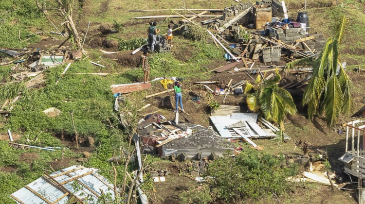
Family members survey their home destroyed by Hurricane Beryl, in Ottley Hall, St. Vincent and the Grenadines, on Tuesday. Beryl is the most powerful storm to form this early in the Atlantic hurricane season.
Lucanus Ollivierre / APHurricane Beryl is tearing across the Caribbean this week, unleashing life-threatening flooding and dangerous wind as it heads toward Mexico’s Yucatan Peninsula.
Beryl has already racked up multiple alarming superlatives. It is the most powerful hurricane ever recorded this early in the Atlantic hurricane season, and also the earliest storm to strengthen so rapidly as it formed. Beryl grew from a relatively weak tropical depression into a full-blown major hurricane in less than two days, sending residents in its path scrambling to evacuate or find suitable shelter.
Climate change is playing a crucial and obvious role in Beryl’s development, scientists say.
“You’re hearing things like ‘unprecedented’ and ‘shocking’ a lot about Beryl,” says Andra Garner, a hurricane expert at Rowan University in New Jersey. But Garner says it isn’t surprising to scientists to see such a big storm so early this year.
Ocean temperatures have been at record highs, largely due to human-caused climate change driven by burning fossil fuels. And warm water is fuel for hurricanes.
“In terms of the science, it’s unfortunately kind of right in line with what we expect when we’re warming the planet and we’re warming our oceans, especially,” Garner says.
Heat drives stronger storms
Beryl was born in the tropical Atlantic. Baby storms need a lot of heat in order to grow bigger and more powerful, and usually there isn’t enough heat available this early in the hurricane season. Most storms in June and July don’t end up becoming major hurricanes. As the ocean slowly warms up over the course of the summer, bigger hurricanes become more likely.
But this year, the water temperature in the tropical Atlantic is off the charts. It’s been in record-breaking territory for over a year, which means there’s a lot of extra heat available to fuel storms.
That heat is what allowed Beryl to become the earliest storm ever recorded in the Atlantic to reach Category 4, and then Category 5, status — with devastating results. At least seven people have been killed as the storm swept across the Caribbean. When it hit Grenada on Monday, Beryl caused “unimaginable” damage, according to the country’s prime minister. The vast majority of the buildings on the hardest-hit islands were damaged or destroyed.
Garner says human activity sets the stage for storms like Beryl.
“When we’re warming the planet with our fossil-fuel emissions, we’re making it more likely that we have those warm ocean waters that can allow a storm like Beryl to really develop and intensify quickly,” Garner says.
Climate change might make rapid growth more likely
Shortly before Beryl made landfall for the first time, it grew from a weak tropical depression into a major hurricane over the course of just 48 hours.
Such rapid intensification is relatively normal for major hurricanes that form in the Atlantic, according to federal hurricane data. “Every Category 5 hurricane that hit this country in the last 100 years was only a tropical storm 3 days [earlier],” says Ken Graham, the director of the National Weather Service. Basically, the biggest storms are likely to gain strength quickly.
What is not normal is the timing. Beryl is the earliest storm to ever undergo that kind of rapid intensification. Usually, rapidly intensifying major hurricanes don’t form until later in the summer and the early fall, when water temperatures in the tropical Atlantic peak and hurricane activity is at its highest.
But climate change may be altering those patterns, perhaps because the ocean has absorbed so much of the excess heat trapped by human greenhouse gas emissions.
“With a warming climate, we should be expecting more of these storms to rapidly intensify,” says Jennifer Collins, a professor in the School of Geosciences at the University of South Florida. But while many climate models suggest that storms will gain strength more quickly as the Earth heats up, it’s still unclear whether that’s already happening. The relationship between a hotter planet and the number and timing of storms that rapidly gain strength is still an active area of research.
Tom Knutson, a senior scientist at the Geophysical Fluid Dynamics Laboratory at the National Oceanic and Atmospheric Administration, says scientists don't have a clear picture yet of the relationship between human-caused warming and rapid intensification. “There may be one that's emerging, but we're not sure."
What is clear is that greenhouse gas emissions are driving ocean temperatures ever higher, and that abnormally hot ocean water early in the summer makes dangerous storms more likely. The 2024 hurricane forecast calls for the most storms ever predicted, largely due to record-breaking ocean temperatures.
“I’m just expecting it to be a whole new season of firsts,” Collins says.
 DONATE


 Support WFYI. We can't do it without you.